0
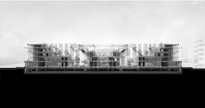
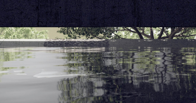
该项目是为山东省某高校软件学院设计一座规模约为三万五千平方米的学习综合体。这是一座校园轴线上的学习综合体,集教学、阅览、集会、演讲、展览等功能于一体,是该校区的核心建筑。这座综合体,不仅承担着教学等基本使用功能,更是整个校园的公共活动中心,并承担着校园门面的意义。我们希望延续校园规划的设计思路,顺应场地特征并创造有活力的空间。 校园轴线沿地势向山坡顶抬升,坐落其上的综合体规模和体量很大,我们不希望它如庞然大物般横插于山腰,成为视线的尽头。所以,我们在中部向下挖出一道锯齿形山谷,恰好能露出后面的山头。考虑到管理和人流条件,我们把阅览区置于南侧,教学区置于北侧,中间通过景观绿庭分隔,而这景观绿庭,恰好成为山水通廊在建筑内部的延伸。景观绿庭结合廊道、空间楼梯和公共平台布置,成为了活跃而宜人的公共空间。我们在中部的“山谷”上架巨型构架,这座阳光大厅成为了最核心的公共活动空间,四周环布“岛式”的学习讨论区和阶梯阅览区,中心的树庭使得上下空间相互联系,并与北侧的山头绿林相映成景。北可观山,南可望海,我们希望营造出具有场地特色的活跃的公共空间。
2
現今發展快速的城市一個個都是以最原始的單體「聚落」發展而成。面對未來動態過程中的多發性,以和種姿態庇護殘存的記憶。透過聚落延續下來的核心價值,模糊秩序化下的街區縫合都市與遺跡,重新時起被遺忘的歷史。基地位於高雄市的鳳山區原日本海軍電信所,基地呈現雙同心圓,但因歷史年代的區劃下已變成分割開的一塊軍事領地,而在這個圓中產生各型態的小聚落行為,而後因都市的改革,直紋面貌的變化從原先的工協新村轉移至垂直住宅,而我們透過線性的梳理形式,產生一座具備與古蹟電信所連結性的育教廊道
這城市被麻痺在粗淺的日常裡,我們身在富饒美好的世界裡卻是那麼地匱乏。我們擁有山河、天地,擁有歷史和記憶,卻是渾然不知的無感。當人麻痺而失速地在土地上不斷覆寫,城市也終漸漸走向失憶而貧瘠的模樣。 我們的城市是由無數的系統、連結重合而成的動態關係;在城市裡不斷變動的關係之間,重合之處的縫隙裡,察覺到了潛隱的世界。透過陌生化的角度,當時間不再是以線性存在,以自身感知重新理解我們腳底下踩的土地,與頭頂上的天空;意識在麻痺的皮層外,時間與土地的完整性。
1
台南安平經歷諸多殖民時期的洗禮之下,擁有豐富歷史,當今觀光產業發達,土地卻也因時間的痕跡不復以往,如何利用廊道空間重新串聯,使新舊共榮,並解決漁光島現今問題。
基地上,溪以北山坡上錯落的旅館,南邊則是較平緩的茶園、平房,原本的強烈對比因為新的建築有重新描述與連結的可能,藉由溫泉與吊橋連接環境,抵達身體。 屋頂藉著貫穿溫泉的樑和山坡的重量懸臂,沿著樑分別通過相反方向的更衣室,來到弧形的水池邊緣,溫泉、熱氣內聚,相同溫度對應漸變的高層,身體探索因坡度變化的感官。兩個入口的矛盾順著溫泉匯集,在最深處,樑和坡面拉開舒適的高度,兩個選擇在這裡交錯。 一段偏移的屋頂,兩道水平漸窄的牆面,使橋的踏面因張力和橋拉開弧形的空隙。身體跟著橋從屋頂之上緩緩沒入橋中,感官跟著橋,從上半身轉換到下,天空到河谷。 因地形,無法互相看見的溫泉和橋,卻在感受重疊;溫泉與橋描述東埔,描述人和自然,藉著建築,編輯成一個可以閱讀和環境緊密的片段。
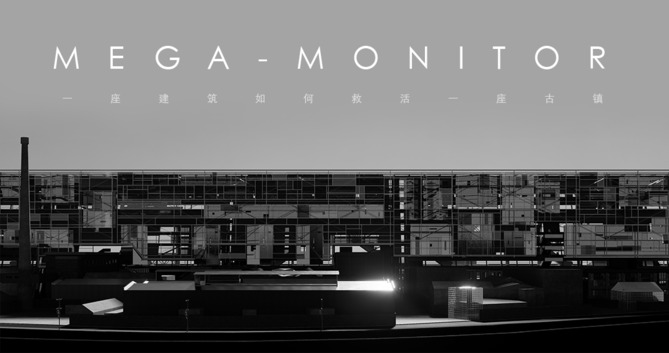
颜神古镇位于山东省淄博市,在现代化工业普及之前曾因陶硫产业而闻名全国,当地独特的烧制工艺与匠人技法赋予了其陶硫产品丰厚的文化价值与艺术属性。 然而时光荏苒,在机械化生产大力推行的今天,颜神镇的手工业生产逐渐衰亡没落,大批居民搬离,徒留一座荒无人烟的古镇和无数破败废弃的工厂。 作品:《MEGA-MONITOR 超显示器》摒弃微小的城市更新手段与针灸式更新策略,旨在打造一座宛如纪念碑式的地标性大体量建筑,整合场地中的零散资源,塑造具有力量感与标志性的建筑形象,营造兼具文化氛围与商业活力的场所,来提升城市形象,重塑古镇品牌,吸引外部资源,创造就业机会,带动当地产业,重现古镇往日蓬勃的生命力。
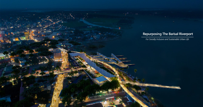
The Second Largest transit port in Bangladesh, once known as Gird-e-Bhandar, Barisal Riverport is slowly losing its driving force after the inauguration of the Padma bridge. By river Barisal-Dhaka takes around 7 to 8 hrs. whereas by road via Padma bridge it takes around 3 hrs. Majority of the riverport user shifted to by road transportation as its more time saving. The port area is surrounded by heavy commercial activity. Due to losing the main driving force it is prone to be exploited by the heavy commercial sprawl surrounding itself. The project aimed to explore other possibilities of the riverport to add values to all the social strata and sustain this 154-year-old history in future urban scenario of the city of Barisal. Large economic development centering Payra Powerplant and the world class tourism vision for Kuakata leads a contributing point for the riverport for the stakeholders of south and the tourist. There is a heavy commercial and administrative zoning as an urban fabric barrier from residential areas to the river. It was a visionary aim to overcome the barrier and give the precious riverfront space of port area to the city people (Along well facilized riverport functions) connecting the vital activity nerves of the city.
3
隨著科技的日新月異,世界沒有停止過演進。 不論工作型態與生活方式都將透過科技和網路時代帶來新日常的轉變。 人類開始追求自己身心所嚮往的完整,他們期待生活與工作可以不再被固定或僵化。於是一種無枷鎖、無邊界、無束縛、處處在生活、處處能工作的模式正在發展與被需要,形成新的數位遊牧時代來臨。於是我開始思考,當背起行囊帶著工作出發前往未知世界單飛的那一刻,除了詩與遠方,能賦予怎樣遊歷在世界的角落等著與他們相遇。
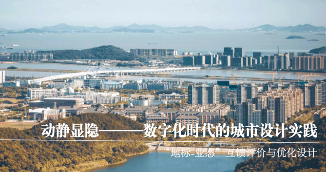
舟山市生活化与未来性的地标丰富,但是不具有典型性,未能形成体系,需要织补成一个网络。因此在全域尺度下,构建地标体系,使其与文化、风貌、交通结构、慢行系统等匹配,并将地标落位在组团进行具体的地标设计。本地段规划为已有特色片区地标体系下的管控单元地标节点详细设计,分别在定海、普陀、新城、北部四大片区选取了16个具有舟山人文、景观特色的地段,基于已有片区结构落位山海廊道、城市特色节点、城市特色大道等,对重点景-观节点进行相应设计,更新现有地标或新增地标,织补舟山地标网络,最终形成具有舟山特色的四十六景地标体系。
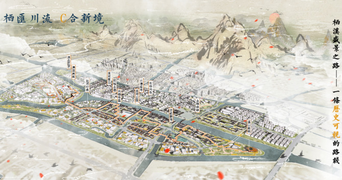
运河史长,蜿蜒南北数千里,途经城镇,桥梁筑立,商户聚集,因而兴盛,故浩浩汤汤数千载而不绝。大运河自诞生初始便于交流和发展紧密相连,担任着悠悠中华的动脉。塘栖自明朝以来就成为了大运河沿线的枢纽城镇,有着“江南名镇之首”的美誉。 在以人为核心的新型城镇化背景下,推进高质量城市化与美好人居环境,塑造多元、开放、高效、优质的城镇空间布局。规划地块位于杭州市北部,京杭运河穿镇而过,而今“大运河国家文化公园战略”与“大运河科创城区域发展战略”的提出赋予了塘栖新的使命, “运河文化+智汇栖水”成为本次设计的主题。 规划前期,设计小组通过实地调研、与当地居民进行访谈问卷等方式对塘栖古镇及A、B、C、D岛进行充分的调查研究,从“文境、人境、业境、场境“四个方面对规划地块进行定性和定量的分析研究,为后期规划设计奠定基础。 规划设计基于总体概念设计和片区城市设计两个层次开展:在总体设计层面,以“城水耦合“为设计理念,从城市和水系的关系展开,研究城市地块和水系的耦合度, 提出“杭州开放门户枢纽,临平智慧创新引擎,运河文化传承高地,塘栖生态示范基地”的四大定位,确定了” 文化塑境的魅力之城、人烟融境的活力之城、科创缔境的智慧之城、蓝绿构境的公园之城“的四大目标,通过对文、人、业、场4个阶段优化与重塑,最终确定总体概念方案。 The canal has a long history, winding thousands of miles from north to south, passing through towns, bridges were built, merchants gathered, so it prospered, so the vast soup has been endlessly for thousands of years. Since its birth, the Grand Canal has been closely linked with exchanges and development, serving as the artery of leisurely China. Tangqi has become a hub town along the Grand Canal since the Ming Dynasty, and has the reputation of "the first famous town in the south of the Jiang". Under the background of people-centered new urbanization, promote high-quality urbanization and a beautiful living environment, and shape a diversified, open, efficient and high-quality urban spatial layout. The planning plot is located in the north of Hangzhou, the Beijing-Hangzhou Canal passes through the town, and now the proposal of "Grand Canal National Cultural Park Strategy" and "Grand Canal Science and Technology Innovation City Regional Development Strategy" has given Tangqi a new mission, and "Canal Culture + Wisdom Huiqi Water" has become the theme of this design In the early stage of planning, the design team conducted full investigation and research on Tangqi Ancient Town and A, B, C, and D islands through field research and interviews with local residents, and carried out qualitative and quantitative analysis and research on the planned plots from the four aspects of "cultural environment, human environment, business environment and site environment", laying the foundation for the later planning and design . Planning and design is carried out based on two levels of overall concept design and lot urban design: at the overall design level, with the design concept of "city-water coupling", the coupling degree of urban plots and water systems is studied from the relationship between the city and the water system, and the four major positioning of "Hangzhou Open Gateway Hub, Linping Intelligent Innovation Engine, Canal Cultural Heritage Highland, and Tangqi Ecological Demonstration Base" are proposed, and "the charming city of cultural shaping environment, the vitality city of people, the wisdom city of science and technology innovation and innovation, and the park city of blue-green construction" are determined" Through the comparison and optimization of the four stages of the scheme, the overall conceptual scheme was finally determined.